|
|
|
|
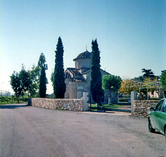


Type: Cross-in-Square
Date: early post-Byzantine period
Description:
This monument is dated to the early post Byzantine period. Nevertheless, it is placed among the Byzantine monuments not only because its date is close to the Byzantine period but also due to its connection with some remnants that prove habitation and rural development in the area during many phases of the Byzantine period.
It is a two-columned, cross-in-square church.
No wall paintings of the period are preserved, apart from one of Hagios Charalampos dated to the 18th century, a work of the school of Georgios Markos.
It is not mentioned in historical sources.
The church had been transferred in a new position, 340 meters in the west, for the construction of the western air corridor in the new airport to take place. Thus, during the excavations realized by the Ministry of Culture in the west of the church, were revealed remnants of a rural settlement with repairs, alterations and annexes that can be dated from the end of the 11th till the beginning of the 14th century. A cemetery was located in the east of these remnants, where the church of Hagios Petros lies. It can be dated from the 11th till the middle of the 14th century, but also much later, during the late period of the Turkish rule. Many graves have been traced inside and around the church.
In the southern edge of the airport and during the excavations of the Ministry of Culture was revealed a middle Byzantine farmhouse, where another building complex existed during the early Christian period. 25 meters in the south of this farmhouse was revealed a rural complex in the northwest of the church of Hagios Petros dated to the 13th century. It must have been destroyed during the end of the 13th and the beginning of the 14th century. Based on coinage evidence (De la Roche treasure), this destruction was generated by the pillage following the capture of the Athenian duchy by the Catalans in 1311. The farmhouse included a tower in its southern side reminiscent of western practices. Consequently, it is a farmhouse related to the presence of a Frankish ruler. This presence may be connected with the reconstruction and the extension of the afore-mentioned middle Byzantine ruins. Besides, their distance is only 25 meters in the south of the Frankish settlement. The rural economy of the area is testified by the big, built earthenware jars, the number of potsherds and other stone findings used for the elaboration of rural products.